Extreme Mediterranean temperatures favoured an attempt at tropical cyclogenesis in the Mediterranean
The Catalonia event of 3–4 October 2026
J. J. González-Alemán, Spanish State Meteorological Agency (AEMET)
Carlos Calvo Sancho, CIDE (CSIC-UV-GVA)
1. Introduction and context
Cyclones with tropical characteristics, known as medicanes, occasionally form in the Mediterranean. Their origin, however, differs from that of tropical cyclones. A medicane almost always starts from an upper-level cut-off low or trough, which destabilises the atmosphere and triggers convection. Only later, through heat fluxes from the sea and latent heating in the storms, does the system acquire tropical features such as a warm core or a symmetric structure (Miglietta et al. 2025). In the tropics, by contrast, a cyclone can be born without that upper-level forcing, from a cluster of highly organised storms that generate their own vortex. This second pathway, which we may call pure tropical cyclogenesis, has never been documented in the Mediterranean, so it would be an unprecedented situation, and the results of this work support this idea.
Between 3 and 4 October 2026, a highly organised mesoscale convective system formed over the sea off Catalonia and produced torrential rainfall in the Barcelona area: 190.8 mm in Barcelona-El Raval (36.1 mm in half an hour), 226.6 mm in Cabrils and 248 mm in Granollers. The event occurred without a cut-off low or a significant upper-level trough, and with the western Mediterranean at record temperatures, 2.5 °C above 1991–2020 in a three-week window centred on 3 October.
Several earlier signals pointed to an environment with potential for tropical cyclogenesis. Météo-France’s AROME model at 1.3 km (00 UTC run of 3 October) developed a very intense convective vortex that reached the Barcelona coast with gusts above 100 km/h. NOAA’s product estimating the probability of tropical cyclone formation within 48 hours showed a signal in that same area. These signals are described in more detail in [LINK: blog article “¿Un intento de ciclogénesis tropical en el Mediterráneo?”].
What the satellite and radar showed
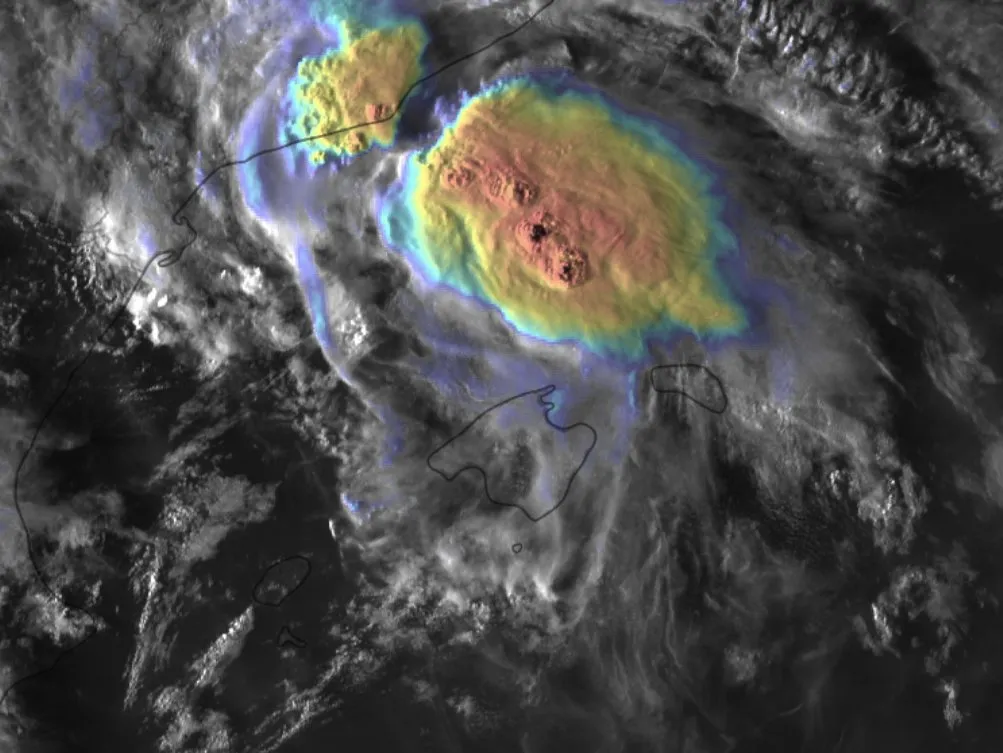
The satellite image of the 3rd (Fig. 1) shows a compact, almost circular cloud shield between the Catalan coast and Menorca, with very cold cloud tops and several overshooting tops in its central and southern sectors. To the west, a cloud band curves around the system. Without the coastlines, the structure would be hard to distinguish from that of a tropical disturbance in its early stages. These powerful storms would go on to show some rotation and a circulation towards the Catalan coast.
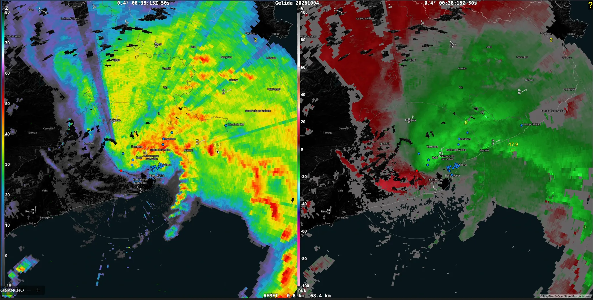
Fig. 2 shows the lowest scan of the Barcelona radar (0.4°) at 00:38 UTC on the 4th, at the height of the torrential rainfall. The reflectivity shows a precipitation band above 50 dBZ that curves from the Vallès to the Maresme coast and wraps around the metropolitan area. Further offshore, other bands with a similar curvature appear. In the radial velocity, an easterly onshore flow dominates, of about 18 m/s off Mataró at less than 1 km height.
The low-level wind field is consistent with a broad cyclonic circulation, 30–50 km across, near the Barcelona coast, although from a single scan it cannot be separated from the effect of the change of wind with height. The underlying question is whether the rotation that these systems usually generate at mid-levels, the so-called mesoscale convective vortex, extended down to low levels. That is the decisive step in tropical cyclogenesis.
Objective
This work does not aim to demonstrate that tropical cyclogenesis occurred, nor to evaluate in detail the realism of the simulation of the event. Its aim is narrower: to determine to what extent the organised convective system, a possible embryo of that cyclogenesis, and the associated rotation depended on the Mediterranean being so warm.
2. Methodology
A sensitivity experiment was carried out with the HARMONIE-AROME model, a non-hydrostatic limited-area model that explicitly resolves deep convection, which is essential to represent a storm system and its associated vortex. Five simulations were run, identical in everything except the sea surface temperature (SST):
- CTRL: IFS analysis SST during the event.
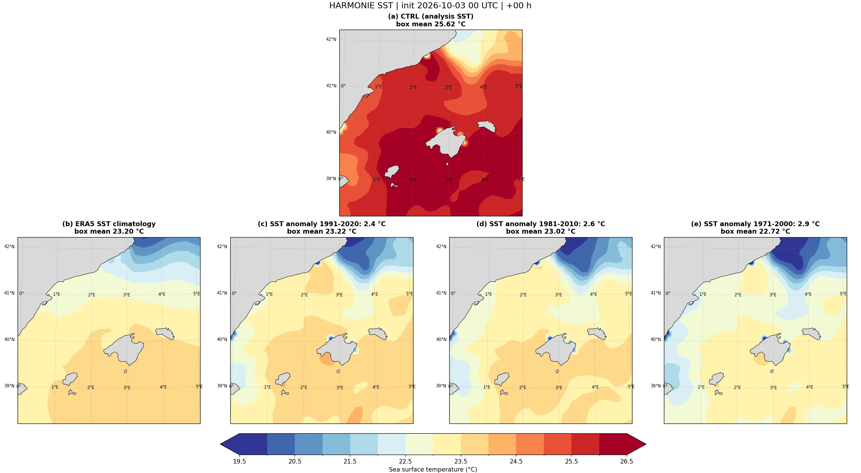
- SSTClim: climatological SST from the ERA5 reanalysis, 1991–2020 average for the same dates (three-week window centred on 3 October), interpolated to the model grid.
- SST reduced uniformly by 2.4 K, 2.6 K and 2.9 K, corresponding respectively to the anomaly relative to 1991–2020, 1981–2010 and 1971–2000. In these three experiments the anomaly was subtracted from the CTRL SST so as not to change the SST gradients.
All experiments share initial and boundary conditions [IFS], a 1500×1500-point domain centred on the western Mediterranean, 1 km horizontal resolution and 65 vertical levels. They start at 00 UTC on 3 October and are integrated for 36 hours. The SST is held fixed during the simulation. Any difference between them can therefore be attributed to the SST. Fig. 3 shows the initial SST of each experiment: the mean over the area shown goes from 25.6 °C in CTRL to 23.2 °C in SSTClim and to 23.2, 23.0 and 22.7 °C in the 1991–2020, 1981–2010 and 1971–2000 anomaly experiments.
Three diagnostics were used for the analysis:
- Infrared pseudo-satellite: simulated brightness temperature, which allows the simulations to be compared with the 10.5 µm channel image from the MTG-I1 FCI and deep convection to be located.
- Relative vorticity at 500, 700 and 925 hPa, smoothed with a 50 km Gaussian filter to reduce noise from individual convective cells.
- Accumulated precipitation: from the start of the simulation, to quantify the surface impact.
It should be borne in mind that the initial atmosphere had already spent days over a very warm sea, so part of its moisture and energy is present in the initial conditions of all simulations. The experiment therefore tends to underestimate the effect of the SST, and the differences should be interpreted as a lower bound.
3. Results
3.1. Organised convection
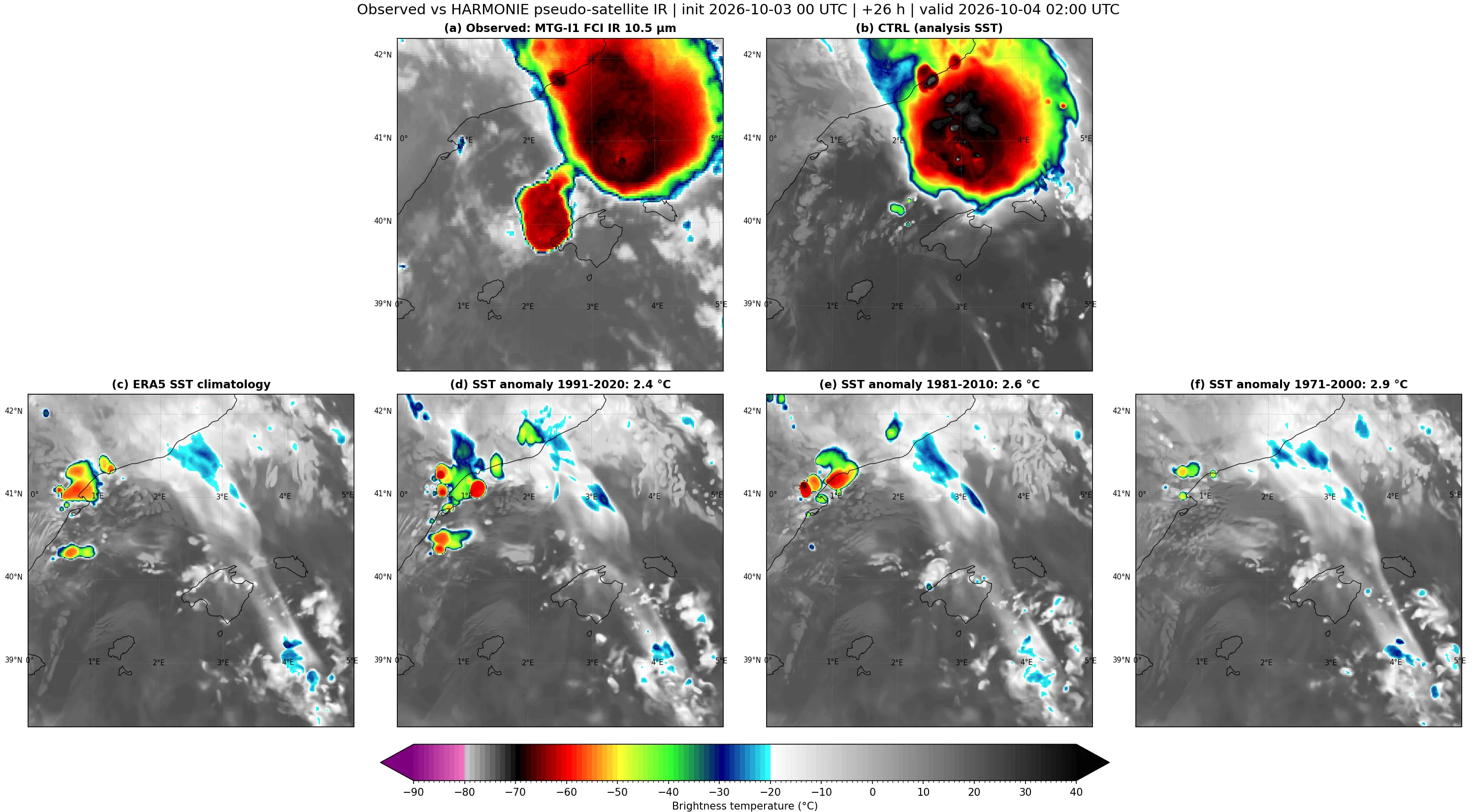
At 02 UTC on the 4th (+26 h), CTRL develops a large, compact, almost circular convective system off the coast of Barcelona and Girona, about 200–250 km in diameter, centred near 41.2°N 3.5°E (Fig. 4b). Its cloud tops are below −70 °C, with cores colder than −75 °C in the central sector, consistent with overshooting tops. Without going into a detailed validation, its structure and position closely resemble those observed by the satellite at the same time (Fig. 4a), although the model does not reproduce the secondary cell observed north-west of Mallorca.
In the other experiments the system does not form (Fig. 4c–f). Only isolated cells appear along the Tarragona coast and off the Ebro delta, with cloud tops of −50 to −65 °C. Further south there remains a north-west–south-east oriented cloud band with relatively warm tops that crosses Mallorca. Convection is somewhat more abundant with the 1991–2020 anomaly (Fig. 4d) and almost disappears with the 1971–2000 one (Fig. 4f). An SST reduction of only 2.4 °C, which preserves the analysis gradients, is therefore enough to prevent the system from forming.
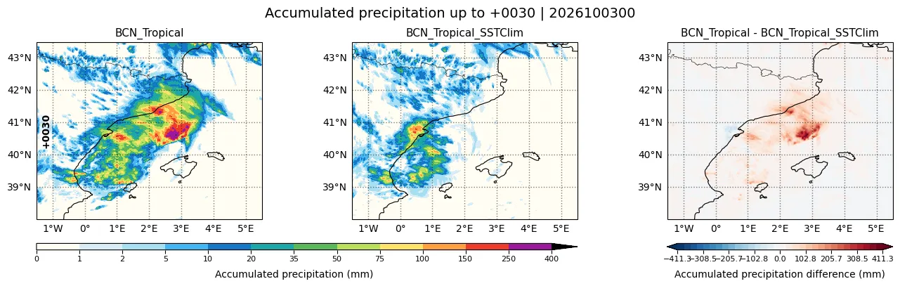
Accumulated precipitation reflects the same difference (Fig. 5). In CTRL, rainfall is concentrated in a broad south-west–north-east band off the Catalan coast, with more than 50 mm over much of the area between 40 and 42°N and maxima above 250 mm offshore, near 40.8°N 3°E, beneath the convective system. Next to the Barcelona coast there is another maximum of 150–250 mm, comparable to the totals observed in the metropolitan area. In SSTClim, precipitation is mostly confined to the area between the Castellón coast and the Ebro delta, with maxima of 75–150 mm, and there is hardly any rain off Barcelona. The CTRL − SSTClim difference exceeds 300 mm in the area of the system and is only slightly negative around the Ebro delta, where SSTClim concentrates its convection.
3.2. Rotation in the vertical
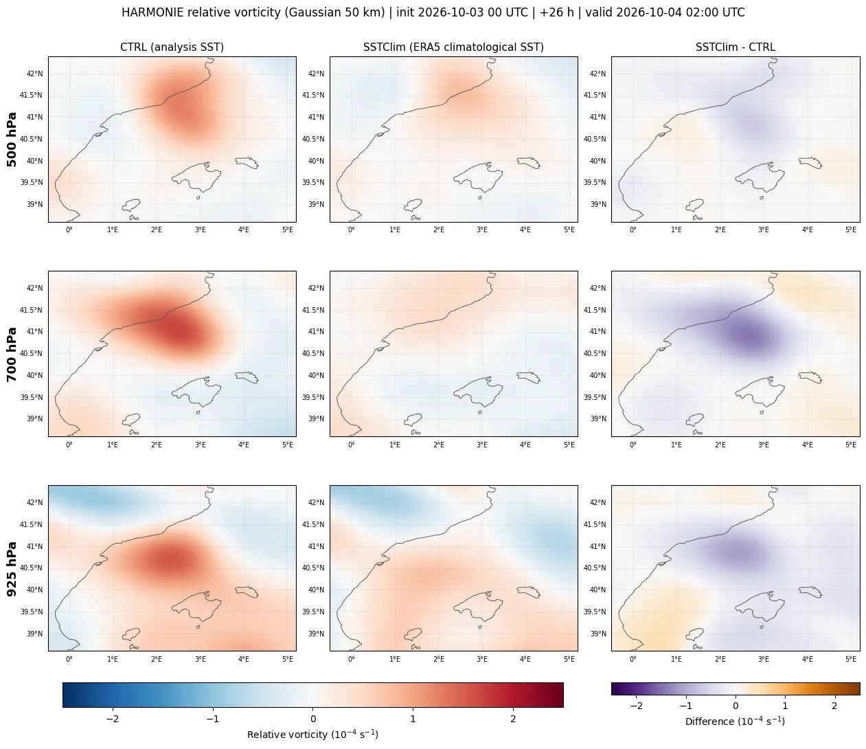
In CTRL, a column of cyclonic vorticity appears offshore, about 50–80 km south-south-east of Barcelona, in the western half of the cloud shield (Fig. 6). It is present at all three levels, with a maximum at 700 hPa of about 2·10⁻⁴ s⁻¹ near 41.0°N 2.6°E, which remains clear at 925 hPa, with about 1.5·10⁻⁴ s⁻¹ slightly further south-west, near 40.7°N 2.3°E. With the 50 km smoothing, these values are 1.5 to 2 times the Coriolis parameter at that latitude. At 700 hPa, and to a lesser extent at 925 hPa, positive vorticity also extends along the coast of Barcelona and the Garraf, consistent with the cyclonic circulation suggested by the radar. The time is close to that of the radar scan in Fig. 2.
In SSTClim there is no organised vorticity. Only weak, diffuse positive values below 1·10⁻⁴ s⁻¹ appear. The difference is negative throughout the vortex area and at all levels, with a maximum of about −1.5·10⁻⁴ s⁻¹ at 700 hPa.
In CTRL, therefore, the rotation is not confined to mid-levels, as in a classic mesoscale convective vortex, but forms a coherent column reaching down to 925 hPa. The 700 hPa maximum is consistent with a vortex that forms at mid-levels and extends downwards, although the temporal order cannot be established from a single time.
4. Conclusions
With the observed SST, HARMONIE-AROME generates an organised convective system off Catalonia, with a structure similar to that observed, and a cyclonic vortex extending from mid-levels to very close to the surface. It also brings totals of more than 250 mm offshore and 150–250 mm next to the Barcelona coast, which almost disappear with the climatological SST. With the 1991–2020 climatological SST neither the convective system nor the vortex forms, and the system does not form either when a uniform anomaly of 2.4 to 2.9 °C is subtracted from the analysis SST. The difference goes beyond a weakening, displacement or delay of the system.
These results do not demonstrate that tropical cyclogenesis occurred, but they are consistent with that hypothesis. Observations showed a tropical-looking cloud structure and a low-level wind field consistent with a cyclonic circulation. In the model, rotation reaching low levels, the piece that distinguishes a storm system from a possible onset of tropical cyclogenesis, only appears with the warm sea. If this interpretation is confirmed, Mediterranean warming could be opening a cyclone formation pathway that had not been considered in the region until now.
Limitations and future work
- A single time from a deterministic simulation. Convection is very sensitive to small perturbations, and part of the difference could be due to intrinsic variability. The experiment will need to be repeated with a small ensemble or with shifted start times.
- Smoothing of the climatological SST. The ERA5 climatology is colder and also smoother than the analysis. It loses mesoscale fronts and filaments that can favour low-level convergence and convective triggering (Minobe et al., 2008). The uniform-anomaly experiments, which preserve those gradients, partly allow both effects to be separated: with a mean SST almost equal to that of SSTClim (23.2 °C, Fig. 3), the system does not form either, which indicates that what is decisive is the value of the SST and not its gradients.
- Vortex dynamics. Its vertical evolution over time, the existence of a closed circulation and a surface pressure minimum, the warm core and the latent heat fluxes from the sea remain to be analysed.
References
- González-Alemán, J. J., Pascale, S., Gutierrez-Fernandez, J., Murakami, H., Gaertner, M. A. and Vecchi, G. A. (2019). Potential increase in hazard from Mediterranean hurricane activity with global warming. Geophysical Research Letters, 46, 1754–1764. https://doi.org/10.1029/2018GL081253
- Miglietta, M. M., Flaounas, E., González-Alemán, J. J., Panegrossi, G., Gaertner, M. A., Pantillon, F., … & Patlakas, P. (2025). Defining medicanes: Bridging the knowledge gap between tropical and extratropical cyclones in the Mediterranean. Bulletin of the American Meteorological Society, 106(9), E1955-E1971. https://doi.org/10.1175/BAMS-D-24-0289.1
- Minobe, S., Kuwano-Yoshida, A., Komori, N., Xie, S.-P. and Small, R. J. (2008). Influence of the Gulf Stream on the troposphere. Nature, 452, 206–209. https://doi.org/10.1038/nature06690
Plain-language summary
In the tropics, hurricanes can be born from a simple cluster of storms. If the sea is very warm, those storms can organise, start to rotate and end up forming a cyclone. This had never been documented in the Mediterranean. The tropical-looking cyclones that form here, medicanes, first need an upper-level disturbance to give them the initial push.
On 3–4 October 2026, a huge storm system formed off Catalonia without that push, with the sea at record temperatures, and left more than 190 mm of rain in Barcelona. Seen from satellite it looked like a tropical storm in the making, and the radar showed winds that could correspond to a rotation near the coast.
To find out what role the sea played, we simulated the event several times with a high-resolution model: once with the sea as it was, and several more with a sea between 2.4 and 2.9 °C colder, like the normal of different periods between 1971 and 2020. With the real sea, the model forms a large storm system with a whirl reaching almost down to the surface. With the sea without a positive anomaly, only a few isolated storms appear and there is no rotation at low levels. We cannot yet say that a tropical cyclone was being born, and the result has limitations that will need to be studied rigorously. But everything suggests that an increasingly warm Mediterranean could start to behave, at times, like a tropical sea and make tropical cyclogenesis possible.